on transit and housing
For Tacoma to continue to be a welcoming city to people who make less than the regional median income, we must plan to build more housing in such a way that all people will be able to afford it, regardless of their income level or family size.
Access to affordable housing and access to transportation options like buses, light rail, bike lanes and sidewalks are deeply related. The old school of thought in real estate was to "drive until you qualify" in order to buy or rent a home, but people who go that route sometimes find that they get more than they bargained for by unwittingly exchanging housing costs for transportation costs.
Proximity is what cities provide. Proximity to goods, to services, jobs, parks and education. There are a wealth of resources at the disposal of Tacomans who can get access to them.
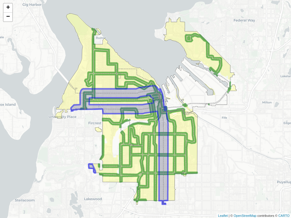
The map above is a conceptual plan for expanded housing options in the City of Tacoma that is based off of a similar concept (Option 2: Transform Housing Choices) now being discussed by the City of Tacoma as a part of the "At Home in Tacoma" project and Housing Action Plan. Disclaimer: While I serve on the Planning Commission, this map is not an official map being proposed currently by the City of Tacoma, and is only a work of art meant to spark discussion.
The yellow areas are where residential development is currently allowed, but is mostly zoned single family. At present that would transition to "Low-Scale Residential" allowing duplex/triplex housing and in some cases 4-plexes as well as townhouses. The areas in blue and green would transition to "Mid-Scale Residential" allowing the development of small apartment buildings (3-4 stories in height) in addition to single family and the other housing types that would be allowed in the yellow areas. The purpose of allowing these housing types is several fold: it expands housing choice, reduces housing cost, gives the option to reduce transportation costs, reduces air pollution from transportation, and helps to reverse historically racist redlining practices that targeted blacks and other minority groups in the area of housing.
The lines on the map are based on existing and future transit service in the City of Tacoma. High Capacity Transit lines, highlighted in blue are planned for Pierce Transit Route 1, which includes 6th Avenue and Pacific Avenues and 19th Street, which is programmed for both bus rapid transit in the mid-term and light rail in the long term. Green areas are regular bus routes.
The size of the housing buffer in each case is informed by how far people are generally willing to walk to transit. In most cases people will walk up to 1/4 mile to transit, which is the width of the blue lines. Regular bus service has been scaled down in this map to only have a 1-block buffer that would allow new apartment buildings.
Feedback on this concept is welcomed. The official At Home in Tacoma project from the City of Tacoma is taking comments on the plan available from the link above until April 9th, 2021. Please email comments on the plan to [email protected].